Features
Hot topics
Incident reports
Wildfire Week
Wind-driven wildfire
The fire that devastated 40 per cent of the Town of Slave Lake, Alta., in May 2011, was propelled by a plethora of weather phenomena from drought and unusually high wind to a bizarre pressure system bolstered by geography
June 11, 2012
By Dr. Ed Brotak
The fire that devastated 40 per cent of the Town of Slave Lake, Alta., in May 2011, was propelled by a plethora of weather phenomena from drought and unusually high wind to a bizarre pressure system bolstered by geography – mountains to the west, prairies to the east – and warm, dry air sitting on top of the Earth’s surface.
 |
|
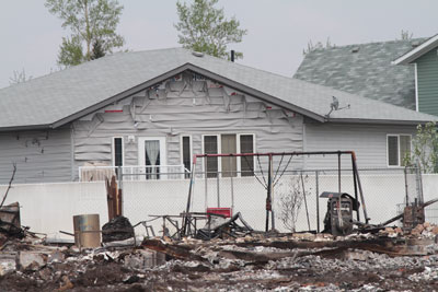
| An unusual mix of wind, warmth and topography drove the wildfire that surged through Slave Lake, Alta., in May 2011. On Sunday, May 15, the weather forecast underestimated the wind speed by 40 kph. Photo by Rob Evans
|
The fire, on Sunday, May 15, desecrated almost 40 per cent of the town. Total losses, which exceeded $1 billion (insured losses of $700 million), made the Slave Lake fire the second greatest natural disaster to affect Canada.
Fire Chief Jamie Coutts gave a harrowing account of the fire – from his perspective on the front line – in the July 2011 issue of Canadian Firefighter and EMS Quarterly. Wildfires are mainly a product of the weather conditions. As a meteorologist, I have incorporated Coutts’s observations into my analysis of the weather conditions that caused the extreme fire behaviour.
* * *
The countryside of north-central Alberta consists of rolling hills. In terms of fire control, this type of topography would present more problems than flat plains, but is not as extreme as more mountainous terrain. The vegetation is mixed boreal forest. With a dry understorey, the spruce trees are prone to crown fires. Drought usually sets the stage for major fires and this was the case in Alberta last year. The North American Drought Monitor indicated moderate drought conditions throughout the region in May. The Slave Lake weather station at the airport had recorded just 75 millimetres (mm) of precipitation in the first four months of 2011. May was even drier, with just 4.5 mm of rain in the first two weeks of the month. The average May precipitation is 43.5 mm and May usually marks the start of the summer wet season. Showing the perversity of nature, an amazing 199.5 mm of rain was recorded in June.
The week before to the fire had been particularly warm; the high temperature had exceeded 20 C on most days (the average high temperature is 16 C). Vegetation was dry and could be easily ignited. Fire ignitions are common in dry but calm conditions, but fire control is usually fairly easy. Unless there is an extreme amount of fuel (downed trees, for example) or challenging topographic situations, fire behaviour is generally normal and spread rates are slow. When high winds are superimposed on a dry area, fire control becomes a problem.
On Saturday, May 14, a number of fires were reported around Slave Lake. Weather conditions weren’t good; afternoon temperatures were above 20 C and relative humidities fell below 20 per cent. Winds from the southeast gusted to 65 kilometres per hour. One fire threatened Poplar Estates, Mitsue and the Sawridge First Nation, which are about 10 kilometres east of Slave Lake. As the fire entered residential sections, these areas were evacuated.
Crews fought this fire through the night and numerous structures were lost. The fire that was to devastate Slave Lake was first reported at 1:30 p.m. on Saturday, about 17 km south of town. The fire was small and, with winds diminishing, crews contained it through the night.
Weather conditions began to deteriorate again after daybreak on Sunday. With a warm, dry air mass still in place (a high temperature of 21 C and relative humidity less than 20 per cent), winds began to increase again. By noon, wind was gusting at more than 60 kph and strengthened throughout the afternoon. By 3 p.m., wind at the airport was sustained at 50 kph with gusts to almost 70 kph. But the fire still seemed to be under control. Then, at 3:30 p.m., reports of a major run started coming in and suddenly Slave Lake was in the path of the fire. Crews were sent to the southeast side of town. With Highway 2 to the south and Highway 88 to the east, Coutts hoped to use these roads as fire breaks.

|
|
| Photo by Rob Evans |
The wider the fire break, the more effective it will be. But wind works against this. Burning debris and embers can be thrown up into the air and carried forward. These embers can carry over a fire break and start spot fires on the other side. Spot fires can merge and become a new, progressive fire head. The stronger the wind, the further ahead of the main fire this can occur.
This is exactly what happened at Slave Lake. By 4 p.m., sustained winds were blowing at 55 kph with gusts of more than 80 kph. The peak gust recorded at the airport was 89 kph. With the wind blowing this strong, burning debris and embers in the air easily crossed the highway and started multiple spot fires on the town side. There were too many fires and too little equipment to fight them. As Chief Coutts recounted, “From the time [the fire] was on one side of the highway until it was burning the town was half an hour. There were too many hot spots and [the fire] was moving too fast.” At one point, Coutts said there were 50 calls and just six trucks.
Another serious impact of the wind on the firefighting effort was to ground all aerial support. By 7 p.m., the wind was too strong and turbulent to allow water bombers or helicopters to fly safely. Poor visibility further hampered the firefighting efforts. Visibility at the airport on the other side of town dropped to a few kilometres in dense smoke.
Another unusual and critical factor was the wind direction. Winds from the east or southeast are not unusual in May, but these winds are seldom strong. All of the record peak gusts recorded in Slave Lake were from the west or northwest. The strong southwest winds became the key factor that drove the fire northward into the town.
The battle against the fire turned in favour of the firefighters that night. First, the exceptionally strong winds died down, as is typical at night. Then, reinforcements arrived to join the fire fight. Finally, fire lines that had been carved into the town held. Unfortunately, this had involved the bulldozing of burned homes, trees and other potential fire fuel. Although some homes were burned in the next two days, most of the 480 homes lost were consumed in that first afternoon and evening.
Why did the winds blow so hard on Sunday? As Coutts recalls, the weather forecast underestimated the winds by 40 kph. Why was Sunday different? To explain this, we must look at the weather maps. Wind is produced by high- and low-pressure areas. Air always tries to go from higher to lower pressure, but something called the Coriolis Effect curves the wind; thus, winds blow clockwise around a high and counterclockwise around a low (in the Northern Hemisphere). The greater the pressure difference, the stronger the winds. Meteorologists can predict this pressure gradient – that is, the change in pressure over distance. It is indicated on a surface weather map by the closeness of the isobars, lines of equal pressure. The strongest winds are found where these lines are tightly packed.
In the week before the fire, a large, strong high-pressure area developed over the Northwest Territories. As is typical in this situation, a nose of high pressure wedged down over the Prairies, banking up against the east side of the Rockies, where it formed a stationary front. Being on the southwest side of this high, Alberta was in a warm, southeasterly flow from mid-week on. Low pressure was located off the West Coast and, initially, the pressure gradient between the high and low was fairly weak. This began to change on Saturday when the low started to move inland. As the pressure gradient tightened, the winds increased. On Sunday, pressures fell notably in British Columbia and Alberta, especially along the stationary front. With pressures remaining high to the east, the pressure gradient across Alberta tightened even more and, as a result, winds were even stronger. Another factor that may have played a role is the channelling effect of the mountains. With the Rockies to the west providing a physical barrier to the airflow, the winds were channeled, or funneled, through a smaller area. When this happens, wind speed increases.
In the Slave Lake region, weather watchers often see a diurnal pattern in the winds. Wind speeds will decrease overnight and then increase again during the following day. At night, when the Earth’s surface cools, the layer of air nearest the surface decouples from the atmosphere above it. These decoupling and frictional effects slow the surface wind. When the sun comes up the next morning, the Earth’s surface is heated, as is the air next to it. This promotes vertical mixing and causes wind speeds to increase.
To get an idea of what weather conditions will be like in the afternoon, it is a good idea to look at a morning sounding, which is a vertical profile of temperature, moisture, and winds. The 12 p.m. GMT (5 a.m. MDT) sounding at Edmonton showed fairly benign conditions at the surface: a temperature of 6.4 C, a relative humidity of 50 per cent, and winds from the southeast at 15 kph. But conditions changed rapidly above the surface. Winds increased to 80 kph at 500 metres (m) above the ground and to 100 kph at 1,900 m. Relative humidities also dropped to 13 per cent at 1,650 m. Conditions aloft on a morning sounding are very important. With the heat of the day and strong mixing, air from above will be brought down to the surface. In this case, dry air and strong winds were poised just aloft, easily available to be brought down. The 12 a.m. GMT (5 p.m. MDT) sounding showed an extremely steep lapse rate (large temperature change with height) from the surface up to three km. This indicated strong vertical mixing and this is what brought the very dry air and strong winds to the surface.
“We never thought this could happen,” Chief Coutts said, “The biggest lesson we learned is we have to plan ahead farther.”
Coutts elaborated the needs from a firefighting perspective.
“I would emphasize the need to lessen the fire risk itself within the confines of the urban area,” he said. “We need to avoid flammable materials. Roofs especially need to be fire retardant. Outdoor areas need to be as devoid of fuel as possible. No dry leaves or flammable mulches. Without reducing the spot fire risk, firefighting efforts will certainly be hampered.”
Dr. Ed Brotak is a retired college professor turned freelance writer. He has studied wildland fires and weather for more than 30 years.
Print this page